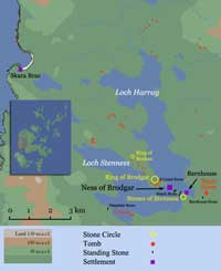


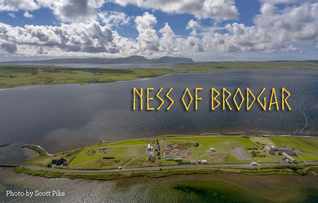
In 2002 a geophysical survey was initiated in two adjacent fields (Areas A & B) on the low ridge that runs down the narrow tip of the Brodgar peninsula, a combined area of about 2.5 hectares. It was part of a long-term project to conduct a thorough Survey of the Inner Buffer Zone 1 of the World Heritage Site, which contains a particularly dense concentration of prehistoric monuments.
Despite being right in the centre of things, the ridge was generally assumed to be a natural feature and expectations were not especially high although prehistoric remains were visible, including a pair of standing stones and a mound that was thought to be the remains of an Iron Age broch. A stone slab with incised decoration typical of the neolithic, had been recovered in 1925 in association with a number of “short cists” that seemed “prehistoric” to their discoverer.
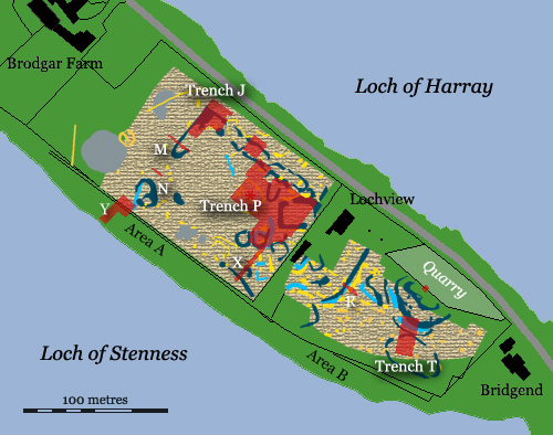
Geophysical Survey of the Ness (Yellow= positive anomalies; Light Blue= negative anomalies; Dark Blue= architecture; Red overlay= trench locations). After Card, 2011.
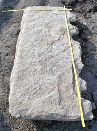
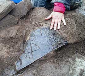
In the Spring of 2003 a crenellated stone slab (opposite right), similar to one found at Skara Brae,turned up in Area A in the course of ploughing. An investigation of the find spot revealed the partial remains of a building with a cruciform layout, similar to that of 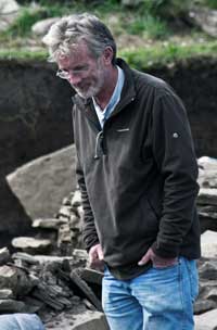 Structure 2 at Barnhouse. This prompted a more intensive resistivity survey that produced dramatic results. Anomalies turned up that indicated the presence of a number of stone structures lying beneath the surface as well as the presence of what turned out to be a massive stone wall that possibly surrounded the site. In short, what appeared to be the ‘natural’ topography of the ridge was almost entirely the result of human activity. Test pits and trial trenches were undertaken the next year (2004) under the direction of Nick Card (right), who had overseen the initial surveys, and these confirmed the general picture.
Given its location, the site must have had considerable importance. The test pits showed that it was completely covered by a thick layer of midden material (domestic rubbish rich in organic material) overlying a deposit of boulder clay laid down during the latest ice-age.
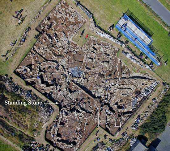
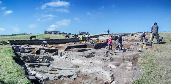
That 2004 campaign turned out to be the first in an annual series that has continued to the present day and is projected to go on for several more years. So far it has produced one game-changing discovery after another. To date less than 10% of the 2.5 hectare site has been excavated, and most of what has been discovered so far belongs to a late phase of occupation. There is undoubtedly much more to come.
The Site
The Enclosure Wall
The geophysical survey in 2003 suggested that much of the site, perhaps as much as two-thirds of the surveyed area, appeared to have been enclosed by walls. However, only short segments of masonry have been revealed so far and these belong to walls running across the isthmus. So far, nothing has been found running parallel to either shore, perhaps the lochs themselves there were considered sufficient barriers. In any case, it is unlikely that the walls were defensive in nature. Perhaps they were used to separate the supernatural world from the mundane.
Trench J from the East with the ‘Great Wall’ in the foreground
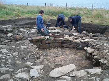
Trial excavations were undertaken during the summers of 2005 and 2006 in order to see what physical trace remained. Trench J in Area A was positioned where the anomaly made its turn and it produced the remains of an enormous construction 4 metres across. with inner and outer faces of dressed masonry and a core of large boulders. It was immediately dubbed the ‘Great Wall of Brodgar’. More of it was found in Trench N, which had been sited across the line of the anomaly as it headed towards 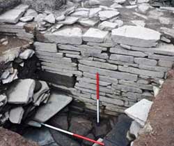 Loch Stenness. At some point, it was doubled in thickness and a shallow ditch 2 metres across was dug in front of it. Most of the superstructure proved to have been ‘robbed’and little survives above a height of 50cm.
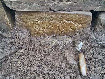
The ‘Lesser Wall of Brodgar’ (left) was identified in the adjacent field (Area B) and a short stretch of it was excavated in Trench R. It is thinner (2 metres) than the Great Wall but survives to a much greater height (1.7 metres in Trench R). It too was ‘double-walled’ with a rubble core. The quality of the masonry was excellent— as good as if not better than that found anywhere else on the site. There was no outer ditch but a series of flagstone pavements fronted the wall.
The Great Wall appears to have been built first since, like the earliest buildings, it was set directly on the boulder clay. The Lesser Wall, on the other hand, rests on the remains of previous buildings. However, there is no archaeological link between the two and no suitable material for radiocarbon dating has been recovered.
Trench J
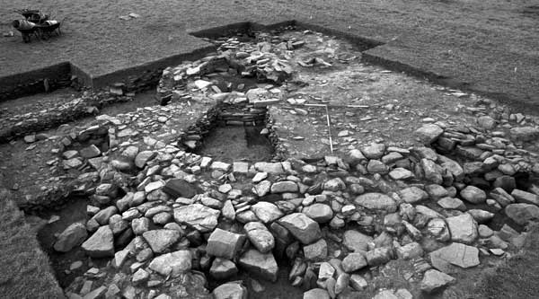
As well as the substantial remains of the Great Wall, those of at least one building (Structure 5) have been identified in Trench J. Excavation has been on-going since 2017 but, as of this past season, it has not been fully excavated.
Trench J, Structure 5: Overhead View (2019)
It was one of the first buildings to be erected on the site. For one thing, it was built on boulder clay and, for another, the Great Wall deliberately avoids it. Although larger than any of them, its construction closely resembles that of Early Neolithic farmsteads found in various parts of Orkney over the year, most notably at Knap of Howar on Papa Westray. Its shape is more ovoid than the latter, but it is similarly partitioned internally by thin, upright stone slabs (orthostats) set into the side walls. The same technique is also a feature of the earliest tombs found on the islands.
Later stone-robbing has made interpretation complicated for now, but two entrances have been identified, both in the southeast side and both subsequently blocked. Excavation of the interior is an ongoing process and still incomplete, so any conclusions about how the building was used has to be postponed for the time being.
Trench P
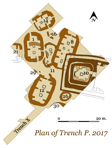
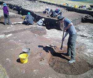
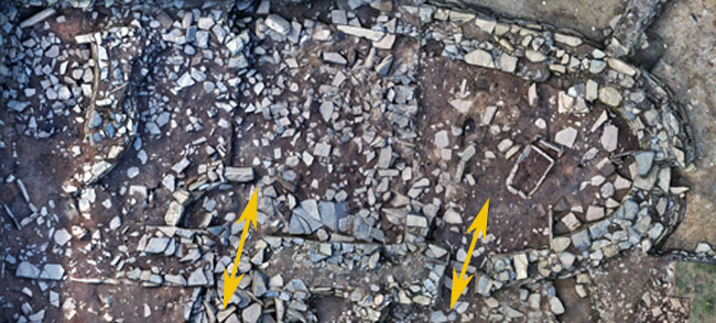
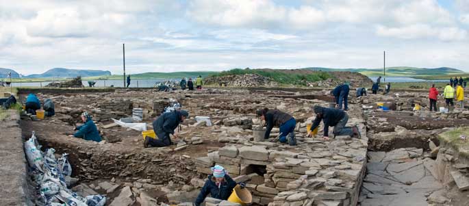
In 2007, it was decided to focus on the interior of the enclosure and to uncover the rest of Structure 1 along with any other architectural remains in the immediate vicinity, so a trench 20x20 metres was laid out and designated Trench P. It has been greatly expanded over the last decade or so and is now several times its original area (and considerably deeper).
Overhead (drone) view of Trench P in 2014. Hugo Anderson-Whymark
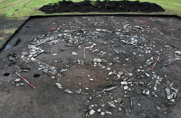
Excavation is far from complete but a minimum of three architectural phases have been identified to date, each of them associated with Late Neolithic Grooved Ware. Even earlier pottery has been recovered from the fill, and so not directly associated with any structures. The earliest identifiable structures have barely been touched by excavation, occurring mainly in sondages. Most of the excavated remains are those of what are known as ‘piered’ buildings because short masonry walls were used to divide up the interior rather than orthostats. The last building erected in Trench P was Structure 10 which represents yet another major change in style— a massive, double-walled structure, with a forecourt in front.
The Piered Buildings
The ‘piered’ buildings were erected in about 3000 BC. They are each oblong with thick walls and rounded corners but there is some variety in size, 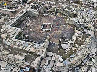 proportions and internal arrangement. They were erected in about 3000 BC and are characterized by dry stone walls a metre or so thick. The latter consisted of an inner and out skin of dressed masonry with a core of soil and rubble. Structure 1 (left) is a good example.
The quality of the masonry was excellent (at least initially) but the engineering was not all that good. No consideration seems to have been taken of the underlying structures and walls were often build over empty rooms, causing them to subsidence. The rebuilds and repairs give the appearance of being hurried and somewhat ramshackle.
The problem of roofing is a much-discussed subject as far as these structures are concerned. The original roofs were apparently dismantled— the walls do not survive to a sufficient height. In any case, organic material such as wood, thatch or turf simply would not have survived under normal circumstances. While timber is very scarce in Orkney today, pollen analysis indicates that this was no so in the Neolithic— initially, at least— and may well have been used for beams and rafters. As far as covering material is concerned, a large number of very thin sheets of flagstone were uncovered in Structure 8, which could have been used as roof tiles. Similar roofs are not hard to find in Orkney today.
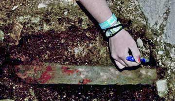
Most of the buildings from this phase had an entrance in at least one end wall. Two of them had another at the opposite end, and two (Structures 1 & 14) had a third in one of the side walls— although this was 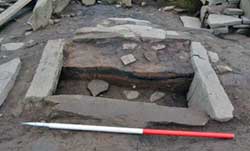 only added after the other two had been blocked. The layout suggests circulation, whether of people or air, through the buildings was an important consideration. There were at least one and often two or more rectangular hearths set along the main axis of each building. They were normally about a metre square and built of stone slabs set on edge, such as the example shown (right) in Structure 7. Hearths have been considered sacred ever since people gathered around an open campfire. Fire provided warmth and protection against the unknown terrors of the night. It enabled them to cook their food and their flames could be used to burn away ‘sin’ to purify body and soul. Fire is also extremely dangerous, however, and the structure of the hearth served constrain its otherwise uncontrollable nature.
The specific function of these buildings is not yet fully understood. The main architectural elements are found in contemporary houses but they also appear in tombs and ceremonial structures such as the nearby Stones of Stenness. There is little evidence of conventional domestic activities, such as food preparation or the manufacture of pottery and tools, so they were probably not meant to be residential. On the other hand, the walls were often decorated and the rooms were well-furnished with the finest pottery. The impression you get is that the buildings were used sporadically but intensively. 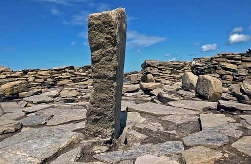
Standing Stone in Trench P
More excavation needs to be done but, at the moment, it appears that the focal point of this part of the community was a solitary standing stone set in an open, paved area between Structures 1 and 12 (above). This was quite clearly a ‘planned’ space and most likely the scene of significant ceremonial activity. Originally known as the ‘Central Midden Area’ it has now become the ‘Central Plaza’.
With the exception of Structure 8, which had partially collapsed, the piered buildings were still in use when the latest building at the site, Structure 10, was erected sometime around 2900 BC. In the meantime, however, they had undergone a fair amount of modification. Some doors were blocked, while others were opened. In the case of Structure 1, a curved wall was inserted to subdivide the interior for some reason. Whatever use the buildings were put to initially, by the time they were finally abandoned their role was apparently much diminished.
The Brodgar ‘Temple’
The construction of Structure 10, known as the Brodgar Temple, would seem to mark a profound change in the nature of the activities carried on at the Ness. It was the last to be built at the Ness and, although the construction methods were similar, it is on an much grander in scale than any of its predecessors. It had a much different design too. Originally the interior was a single squarish room (c.15x15m.) with rounded corners— similar to House 1 at Skara Brae or House 8 at nearby Barnhouse— but much larger than either.
Excavations in Trench P, Structure 10 (2012). Photo by author.
There were several phases in the history of the building— although the interval between them has not yet been determined— and it was remodelled more than once. After the central structure was built (perhaps immediately after) it was encased on three sides by an outer wall that created a narrow, 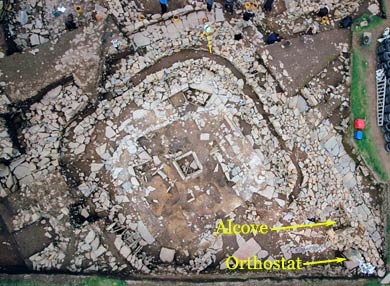 paved ‘ambulatory’ that ran around the perimeter. At some point, the wall was extended on both sides to create what appears to be a forecourt. The northern wall has not been excavated beyond the limits of the trench and the southern one has not been excavated at all so it is impossible to say how much further this court projects. Nor do we know whether or not the alcove and standing stone on the northern side is mirrored on the southern one.
The interior was thoroughly remodelled some time later to create a cruciform arrangement of alcoves. There was a stone-lined hearth in the centre of the room and a stone ‘dresser’ in each of the alcoves, similar to those found at the contemporary site of Skara Brae. At the Ness, the ‘dressers’ were free-standing rather than placed up against the wall. The terminology derived from the type of stone furniture used in Orcadian farmhouses until relatively recently. In this case, however, they could probably be better described as ‘altars’
As was the case with the piered buildings, Structure 10 seems to have been used intermittently and sat abandoned for a century or so before it was largely dismantled, along with the surviving piered buildings. The ruins were finally filled with dumps of rubble and midden material. Then a carefully arranged deposit of cattle bone— representing as many as 400 individual animals— was placed around it. The bones had been butchered and the meat cooked, probably representing the remains of an enormous feast that marked the formal decommissioning of the site. The idea of an immense steak barbecue for hundreds of people certainly is certainly appealing.
Trench T
General View of Trench T in 2017.
In 2013, a new trench (Trench T) was opened in Area B to run from a double-walled anomaly by the modern quarry towards Loch Stenness with the aim of discovering its nature. Located about 75 metres southeast of the main excavations in Trench P, Trench T cuts across a mound of Neolithic midden ca. 70m in diameter and over 4m thick, the organic waste product of domestic occupation. The same material was found to overlay the buildings uncovered in the main excavations in Trench P, so there was every reason to expect architecture here as well.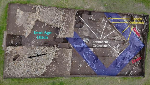
Aerial of Trench T at the Ness of Brodgar (based on an original photograph by Hugo Anderson Whymark)
In 2013 it was decided to dig a trench from the top of the mound southwards towards Loch Stenness. At the top of the trench, dug into the midden, was a stone-lined ditch of Iron Age date— similar to the sort of thing found at many of the nearby brochs belonging to the same period. In the southern part of the trench the archaeologists encountered a large number of pits— at least 50 have been cleared to date. Some of them were stone-lined and all of them had been refilled with the same midden material. Their purpose remains a mystery.
In 2015 traces of a much earlier building, Structure 27, started to emerge. Its rectilinear layout and construction of the excavated walls, which apparently consists of parallel rows of upright orthostats (stone slabs) with a rubble interior. Its rectilinear plan is at odds with the norm at the Ness but close parallels do exist quite in the nearby chambered cairn at Bookan. The trench has been steadily enlarged since then in order to further define its nature and function.
Future Exploration
Barely 10% of the area of the site has been investigated to date but there is much more work to be done— several season’s worth, at any rate. The trenches currently under excavation will be fully explored and there will undoubtedly be some expansion. Nevertheless, with a site of this size and importance, it is best to leave plenty for future generations with more advanced techniques to explore.
Suggested Reading
| Card, Nick | (2005) | Excavation of Bookan chambered cairn, Sandwick, Orkney. Proc. Soc. Antiq. Scot. |
| (2011) | Ness of Brodgar, Stenness, Orkney Excavations 2011 Data Structure Report, ORCA 271. | |
| (2017) | To Cut a Long Story Short: Formal Chronological Modelling for the Late Neolithic Site of Ness of Brodgar, Orkney, European Journal of Archaeology, April 2017 | |
| Davidson, A.L. & A.S. Henshall | (1989) | The Chambered Cairns of Orkney |
| Garnham, Trevor | (2004) | Lines on the Landscape, Circles from the Sky |
| Renfrew, Colin (ed.) | (1985) | Prehistoric Orkney |
| Richards, C. (ed.) | (2005) | Dwelling among the Monuments |
| (2013) | Building the Great Stone Circles of the North | |
| Richards, Colin & Richard Jones (ed.) | (2016) | The Development of Neolithic House Societies in Orkney |
| Thomas, Antonia | (2016) | Art and Architecture in Neolithic Orkney: Process, Temporality and Context |
| Wickham-Jones, C. | (2006) | Between the Wind and the Water. World Heritage Orkney |